Addressing flood risks in Boston through reuse of outmoded street space

This proposal was developed as part of the EcodesignX course from the University of British Columbia.

This map of predicted flood risk areas as soon as 2050 with a major storm is a striking reminder of Boston’s climate-related challenges in the future. The city will need to determine how it will handle a predicted sea level rise of 3-6 feet by 2100, especially in the Seaport District and the South End, which are shown below and are at risk of nearly complete flooding.

Screen Shot 2017-04-21 at 3.30.47 PMFollowing the model of the New Orleans Urban Water Plan and the “Making Room for the River” plan in the Rhine region, my proposal is for the accommodation of water in these two neighborhoods through the use of canals which will be designed to flood and let water in, not attempt to keep it out.

Screen Shot 2017-04-18 at 11.50.57 AM.pngScreen Shot 2017-04-18 at 11.51.26 AM.png

These photos show Harrison Avenue (left), a main thoroughfare in the South End, and Seaport Boulevard (right), the main road in the Seaport District. These roads are very wide with large medians and lane widths. Built in the 1960s when these districts were primarily industrial centers to accommodate trucks, they have become outdated as the neighborhoods’ land uses shift to residential and retail uses. The design of these roads have become detrimental to the quality of life and attractiveness of these areas. By removing the medians as well as excess lane width (shrinking the lane width from 12 to 9 feet, for example) and using the space for canals in the middle of the road will serve as both a strategy for constructively incorporating new water into the urban fabric and improving the built environment and the overall attractiveness of the neighborhoods and their public realm.

Canals in Venice (see below) serve as a major attractive feature of the city, and also allow for a new mode of transportation. These canals, in addition to accepting water and beautifying the streetscape, can be used as a method of transportation in these congested and auto-reliant districts. The canal system will allow the Seaport District and South End to be more connected to the water around them as opposed to in conflict with the Harbor and Back River. New water in the districts will be a useful and attractive asset for new residents, and could establish much needed neighborhood identity and character in the Seaport.

A Reflection: The Shortcomings of City Government Community Engagement

When a city conducts a regional or neighborhood-specific community outreach project, visibility and accessibility must be top priorities. In order to maximize reach and response, a city government must allocate all available resources to this purpose, or else run the risk of an initiative conducted in vain should it fail to reach a significant portion of the population. Such projects are either discarded as an expensive

C6_Ti_OVwAAXJnG
A mostly empty auditorium for a Hayward, California design charrette

waste of time, or worse yet published as if reflecting a comprehensive view of citizens opinions. Currently, initiatives in the City of Boston and around the nation (see right) are reaching only a tiny percentage of the population affected by a planning process. This may be considered passable in today’s City Halls, yet it is a fundamental failure. Design charrettes and “brown-bag sessions” that are part of these planning processes are often attended only by two or three groups- the suit-clad government officials and their friends, the public meeting regulars whose opinion is heard loud in clear in every meeting and survey, and perhaps a handful of college students of urban planning or architecture. Strikingly missing from engagement events, and likely from surveys and comment periods, are the actual citizens of the area involved.

This is especially true regarding young people and immigrant communities (whose members do not speak English confidently or at all). These groups are most in need of new affordable housing options and most vulnerable to rises in rent. Reaching these groups should be the top priority of community engagement. And in some processes like Go Boston 2030, an effort was made to break the language barrier and to engage with citizens on the street who may not have the established contacts needed to relay input through traditional channels or hear about public meetings. However, whether by lack of knowledge, timidness, or scheduling constraints, the vast majority of young people and recent immigrants do not have their voices heard in even the more accessible initiatives.

Therefore, all resources and funding must directed to designing processes that, above all, prioritize visibility. Posters or billboards on busy pedestrian thoroughfares, ads on the subway, postcards on tables at coffee shops- these types of info sources, visible at all times and seven days a week, must be where a large portion of available funds for design and implementation is spent. Hiring a world-class firm to design a plan compiled from public input is a waste of money if the words of the plan do not reflect the the public’s opinion and if no members of the public are actually reading the plan! Additionally, engagement processes which remain tedious and unclear (in Boston, most notably the hidden and confusing comment system for proposed development projects) must be easily accessible by text, Twitter, Facebook, and other forms of communication that may be unique to certain communities (like WeChat and Facebook Messenger for Chinese-Americans).

For governments to truly be transparent and cognizant of their citizens questions, comments, and concerns, community outreach programs must permeate the daily routine of those they are meant to reach. Th

IMG_1395-e1454618924836
“Ideas on the Street” pop-ups, a part of Go Boston 2030’s on-street outreach

is requires in-depth knowledge of local communities, and long-term (not one-time) outreach and advertising efforts. It is much more than a hard to find link on a city website, more than a 6 p.m. public meeting at City Hall, and even more than working with local community institutions. In order to reach the disenfranchised and most vulnerable whose voice must be heard, engagement must be conducted as people are walking down the street to work or to school, while shopping, while eating, at all times. Residents whose voices must be heard above all others (such as young people and recent immigrants) do not have the luxury to attend public meetings or the clout to access traditional feedback channels. Creative engagement systems like those of Go Boston 2030 (see right) are a start. However, for the City to reach its most vulnerable and most often silent, it must be ready to work towards (and be ready to accept) a small-scale yet permanent process as simple as reading a question on the street, scanning a QR code and sending off a quick reply- all without being late to work.

The Power of the Local Theater

Among the strongest drivers of vitality and vibrance within cities and towns is youth presence: college students at festivals like Boston Calling, or high schoolers flocking to a new Mexican place. However, young people who are excited to get out and explore the communities which surround them are strikingly (and tragically) missing from areas which need them most. As America’s rural and suburban “main streets” continue to deteriorate and attractions become increasingly sprawled, more and more young people are abandoning town centers for other meet-up spots. As a result, the decay of historic towns such as North Conway, New Hampshire worsen without the diversity and vitality that youth bring. Often underfunded and poorly managed, local institutions with the power to encourage youth to play a role in urban vitality such as the North Conway Twin Theatre, fall into ruin.

IMG_2481.JPG
The closed Twin Theatre in January 2017

Other towns have checked this cycle, with local leaders and groups rallying to save institutions which have long played a role in nurturing a livable street environment. Like in North Conway, the Capawock and Island theaters of Martha’s Vineyard (in the towns of Vineyard Haven and Oak Bluffs) went out of business in 2012- then decrepit eyesores. However in 2015, a local group arose to solicit donations in order to completely renovate and reopen the theaters. The results of the process are impressive- modern, well-maintained, air-conditioned theaters with a wide selection of snacks and drinks at a reasonable ticket price. Since the re-openings, one who journeys to the Capawock Theater on Main Street in Vineyard Haven any weekend (or any night throughout the summer), will find lines stretching down the street. The theater, and its surroundings, are often abuzz with the excitement and enthusiasm of the many groups of friends, families, and couples waiting for entry into the theater.

img4be1d48a34000
The Capawock Theatre after reopening in 2015

The effects of this new enthusiasm surrounding Vineyard Haven’s Main Street stretch from increased perceived safety (see ‘Eyes on the Street’), to a boost in foot traffic which benefits other Main Street retail, to increased property values of nearby apartments. All of these benefits contribute to only more vitality, kick-starting a cycle of true “urban renewal”. Other towns, such as Conway, New Hampshire, (10 minutes south of North Conway) are following in the footsteps of the group on Martha’s Vineyard. Conway’s historic Majestic Theatre is slated to be renovated and reopen to the public after going out of business and being declared unsafe. With the local businesses surrounding the Majestic struggling, the theater should provide a much-needed boost to the vitality (and as a result, economic stability) of Conway’s Main Street.

screen-shot-2017-01-19-at-8-13-31-pm
The Majestic Theatre in Conway is surrounded by local cafes and shops which have a lot to gain from increased foot traffic on the street

If rural towns such as North Conway wish to expand their hours of activity from around nine (mainly gift shops and general stores) to a broader 12-15 hours- bringing increased economic opportunity and livability- leaders must look to Martha’s Vineyard and establish a committees to reopen institutions such as the Twin Theatre. The young people who will inevitably come along with a well-run public amenities like theaters will be well worth the investment.

Image credit americantowns.com and Google Street View

Looking to Shanghai: Best Practices for Inspiring a Transit-Oriented Generation

As a teenager and young citizen, I have a strong and direct connection with the next generation. Among high school and college students like myself, the realities of climate change are widely accepted, and we are are prepared to take action. Perhaps the most important action young people are ready to take is to choose public transit over private transportation. Unlike our Gen X parents, members of Generation Z are willing to take the train or bus, and to live in denser areas closer to public transportation options.

In my home state of Massachusetts in the US, those headed to college are eager to study at urban universities. The populations of Massachusetts’s cities are booming again, with the fastest growth occurring in areas well served by transit. However, Boston’s transit system (like those across much of the US) is unprepared to handle this remarkable opportunity to keep young people out of cars and encourage a significant reduction in greenhouse gas emissions. The MBTA (Boston’s transit operator) uses trolleys and cars from the mid 1980s. Engine fires and breakdowns in snowy conditions are common. Even when the trains are running, they operate at a sluggish pace. Frustrated riders peer out train car windows and see cars speeding by on the highway. So many young people who would be willing to embrace denser living and public transit are discouraged from doing so by the inconveniences of outdated technology. In order to make a major transition away from cars and towards transit, young people need support from practical and effective public transportation options.

In China, the massive rural-to-urban migration continues, with over 100 million (mostly young) Chinese beginning their lives in megacities each year. Cities like Shanghai have designed their transportation systems to meet this heightened demand with transit. On a recent visit to Shanghai, I rode these rail systems, which my peers would choose any day over their private vehicles.

Shanghai’s Metro system and Maglev train should be considered paradigms for sustainable transport in growing cities. Here, the technology of the system fosters high ridership. The Metro runs with efficiency and speed that encourages all Shanghainese- young and old, rich and poor- to mold their lives around their transit system. LED signs and cutting-edge passenger information systems utilize tracking hardware to provide up-to-the-second train arrival updates. Technology aboard the train cars run frequent diagnostics and detect faults that reduce delays and have all but eliminated the disabled trains and equipment failures so common to American systems. Since its inception in 1995, the Shanghai Metro has experienced only two significant technological malfunctions affecting service. As a result, the trains run quickly and provide uninterrupted efficient transportation across the city for nearly 8.5 million riders per day.

While the Metro provides a model for sustainable urban transport, the Maglev train is realizing a future of transit-based intercity travel. Connecting Shanghai to its suburban airport, the Maglev has demonstrated the potential for technology to make the automobile all but obsolete for long-distance travel. Running on electric power that can be generated by a multitude of clean sources, the environmental benefits of magnetic levitation include reduced noise pollution and land use, as well as total elimination of CO2 emissions. However, the most critical aspect of the Maglev is its speed. The train operates throughout the entire day at over 400 km/h (250 mph), nearly 300 km/h above highway automobile travel. The train is reliable and most importantly, the quickest option. This is critical—engineers can design a transportation system that is environmentally sustainable, but it will have no beneficial effect unless it is also practical. Shanghai has demonstrated how to build a system that is both.

In Massachusetts and elsewhere, young citizens await a viable public transportation option. They are ready to embrace automobile-free living, and must be encouraged to do so. Cities like Boston, Los Angeles, the San Francisco Bay Area, Toronto, and others must look to models around the world such as the Shanghai Metro and Maglev. Such transit systems represent a pathway for turning the opportunity of global urban migration into a meaningful reduction in (and potentially elimination of) transportation sector carbon emissions, which make up 26% of US greenhouse gas emissions.

The Changing Face of Boston’s Industrial Neighborhoods

Fighting the wind on a cold December afternoon, planners and officials from the City of Boston meandered down Braintree Street, an unassuming Allston backstreet running parallel to the Massachusetts Turnpike. In the midst of a walking tour for the city’s Imagine Boston initiative, leaders such as the Chief of Arts and Culture as well as representatives from the BPDA and Harvard detailed the street’s current status and the plans for its future. Rising on the street today is an 80-unit apartment building targeted towards young professionals and grad students. The developers claim that the apartments, mostly studios and one-bedroom units, will cater to those who cannot afford to pay the luxury rates of Troy Boston or Ink Block closer to the city center. The multi-story development will stand out among much of its surroundings, which remains primarily industrial. Repair shops, moving companies, delivery truck lots, and other traditional industrial institutions still make up the majority of the street, rising no more than a story from the ground. It seems almost certain that such businesses have only a short time

Screen Shot 2016-12-05 at 6.15.05 PM.png
The 1970 Boston Land Use plan showing Allston’s industrial (purple) roots

left on Braintree Street before a new developer comes knocking, eager to snatch up land on which to build more housing. Many city officials and those behind Imagine Boston are praising this transition. With housing prices skyrocketing and the city’s population growing, a housing shortage is imminent unless areas of the city which were not traditionally residential are converted to units Boston desperately needs to house the 35,000 who move in each year. For Imagine Boston, the solution is continuing and expanding the conversion of traditionally industrial areas such as Braintree Street, Newmarket, the South End, and the Seaport to mixed-use neighborhoods. These areas of the city are already facing increasing pressure to sell their valuable, centrally-located land to (often luxury) housing developers. Just this year on Harrison Avenue in the South End, Ho Kong Bean Sprout Co and Quinzani’s Bakery, longtime suppliers of the Boston’s restaurants, joined many other long-established businesses in selling off their valuable real estate. For Ho Kong and Quinzani’s clients, this just means finding a new supplier, likely further from the city center like Piantedosi Bakery in Malden. However, for many of the immigrants (mostly Chinese) who were employed there, the transition will not be so simple. Losing their jobs will put an even greater stress on their budgets, already strained by ballooning housing costs in Chinatown and elsewhere. Like the bakeries, recent immigrants may find themselves forced to relocate from traditionally immigrant-friendly neighborhoods in the city center such as Chinatown to suburbs where rent is more affordable. Meanwhile, white middle and upper-middle class suburbanites are eager to move to take their places, at Ink Block in the South End, at 61-83 Braintree Street, and at One Greenway in Chinatown.

img_1964
The Ink Block luxury apartments behind Quinzani’s Bakery on Harrison Avenue in the South End


With low-rise, low-density industrial neighborhoods in danger, the only choice for this section of Boston’s economy and urban fabric to remain is for traditional industry to be replaced by institutions such as the 119 Braintree building. Just steps from the new development on Braintree Street, a new type of industrial land use is being prototyped. In contrast with traditional low-density industrial development, 119 Braintree rises multiple stories, accommodating businesses such as light manufacturing, graphic and interior design, photography, and architecture. The unassuming building represents a shift in what defines ‘industrial’ land use in Boston, a shift that has already reshaped New York’s neighborhoods.

exterior-3
The multi-story 119 Braintree Street building

Like in Brooklyn, where shipyards have been replaced by notebook manufacturers and auto repair shops with chocolate makers, Boston must be prepared for a new type of industry that can withstand development pressures and can accommodate the City’s needs as it grows. However, the City must be sure that the new “evolved” industry and new housing is inclusive. Ensuring low-income and recently-immigrated citizens have access to entrepreneurship and employment opportunities as well as affordable housing is crucial to preserving the diversity and historical character of Boston. The industrial transition must be an central part of the City’s efforts to do so.

In the coming years, this transition will transform Boston physically, economically, and demographically. The Imagine Boston 2030 plan must lay out the City’s response to these changes. Should the city take measures to preserve long-established industrial land uses alongside new development? Will there be a response to growing pressure on low-income workers threatened with being priced out of their traditional neighborhoods? Or will the City let the market determine its future? For Marty Walsh, the answers to these questions will define his mayorship and its legacy.

Bridge Market: A Hub For Seaport Seafood

This proposal was a finalist in the Northern Avenue Bridge Ideas Competition, an initiative by the City of Boston and the Boston Society of Architects. The entry was originally published here.

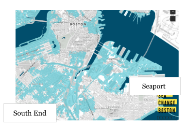
Seaport is perhaps the most rapidly changing neighborhood in Boston. Once an industrial center, then a parking lot with harbor views, and today a burgeoning tech and innovation center, Seaport has had quite a tumultuous past. However, little evidence of these phases in the district’s history (despite their onetime dominance) appears on the streets of Seaport today. Still, one artifact remains. Just as it links Seaport to the Financial District, the Northern Avenue Bridge links Seaport to its past. The Union Freight Railroad once carried the spoils of the district, often seafood, to Downtown Boston and beyond. With Seaport undergoing rapid, dramatic development, it is time for the bridge to once again become a vital piece of Seaport commerce.

My proposal aims to recreate the commercial hub which the bridge once was, honoring its history and its connection to Seaport commerce while also creating a shopping destination for all residents (both new and longtime) of the district. To do this, the bridge should be repaired and become Bridge Market, a “fisherman’s market”. Of the three central passageways on the bridge, the outer two would become space for Seaport seafood vendors to set up shop. These vendors would serve Bostonians from food trucks, which could be driven off of the bridge every day to be resupplied. The central passageway would be left as an area for pedestrians to browse the market and make their way across the Channel. The market would look similar in form to a farmers market, such as the one at Dewey Square.

Through the vendors at Bridge Market, the entire Seaport district would be represented. Longtime local fisherman currently selling their daily catch at the Boston Fish Pier just a mile down Seaport Boulevard would be given another outlet to sell their seafood, and an opportunity to sell directly to the people of the District. Beloved Seaport seafood restaurants such as The Barking Crab and Yankee Lobster would also be given an opportunity to expand. Such businesses, facing the upheaval of new development, would be able to cement their place in the District, and in the process preserve the character of historical Seaport. For sale on the bridge could be both prepared food for lunch, dinner, or snacking, as well as unprepared food for people to bring home and cook themselves. Such a model worked well in New Bedford, where the Fisherman’s Market was a hit, providing office workers with fresh cod and shellfish to bring home to their families.

As Bridge Market, the Northern Avenue Bridge would serve as an iconic entrance to the Seaport district, similar to the Chinatown gate. Visitors to Seaport, with its unvaried and often uninviting steel-and-glass towers, will find an open, human-scale, and interactive contrast in Bridge Market.

Development in the past and present has left little room for the history of Seaport to endure. A “Fisherman’s Market” would prevent more of the classic Seaport from slipping away in the face of new development. Repurposed as Bridge Market, the Northern Avenue Bridge would become a destination where Seaport’s past and present meet and exist alongside each other in harmony. At Bridge Market, the seafood of Seaport’s past can live on through new favorite food trucks and vendors. Bridge Market would provide new opportunities for food trucks, already a huge hit around the city, to expand into a new sector. It would be the 19th and 20th century food of Seaport, presented through the 21st century style of service. As Bridge Market, the Northern Avenue Bridge would symbolize Seaport’s past, an ode to the fishermen and longtime seafood institutions of the South Boston Waterfront.

Bridge Market could be built in two different ways, depending on the expected number of vendors and the eventual budget. The first option would raise the bridge higher in order to accommodate the 16-foot height requirement; however, this could cause difficulty due to ADA requirements. The other option, which includes demolishing the two non-moving sections and replacing them with pedestrian bridges, could solve this accessibility problem but would leave less space for vendors. In order to make the correct decision on the design, cost and demand factors must be considered.

Preserving and revitalizing the Northern Avenue Bridge as Bridge Market could play an important role in preserving the industrial history of the Seaport District itself. As the Union Freight Railroad once linked Seaport and the Financial District through the transportation of goods in the 1800s, Bridge Market could do the same today.
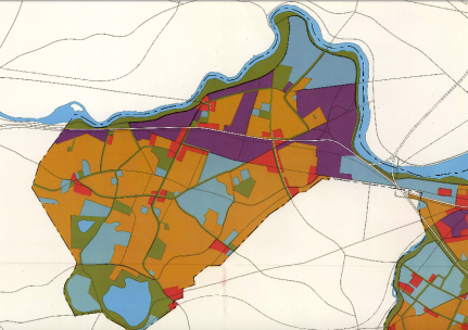